^ 关注我,带你一起学GIS ^
注:当前使用的是 ol [9.2.4] 版本,天地图使用的key请到天地图官网申请,并替换为自己的key
 前言
前言
❝
GeoJSON是一种用于编码各种地理数据结构的格式,采用JSON方式表示。在WebGIS开发中,被广泛应用于数据传输和共享交换。
1. GeoJSON数据格式
GeoJSON对象类型多样,具有Geometry类型:Point、LineString、Polygon、MultiPoint、MultiLineString、MultiPolygon以及GeometryCollection,要素类型Feature和要素集类型FeatureCollection共九大类。几何对象(Geometry)加上属性信息(Properties)构成要素(Feature),要素集(Features)组成要素集合(FeatureCollection),其逻辑关系如下图。
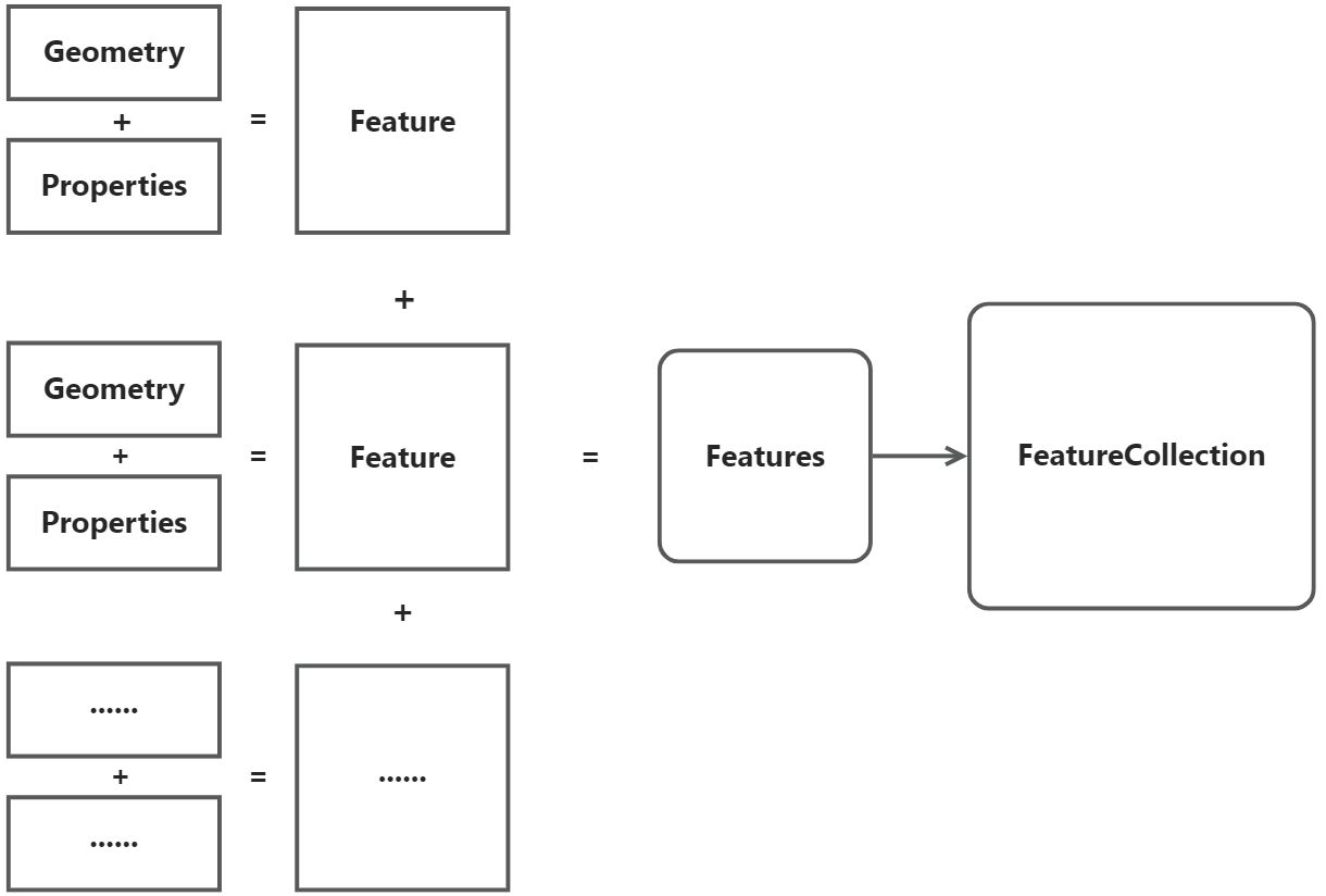 图1几何对象组成结构图
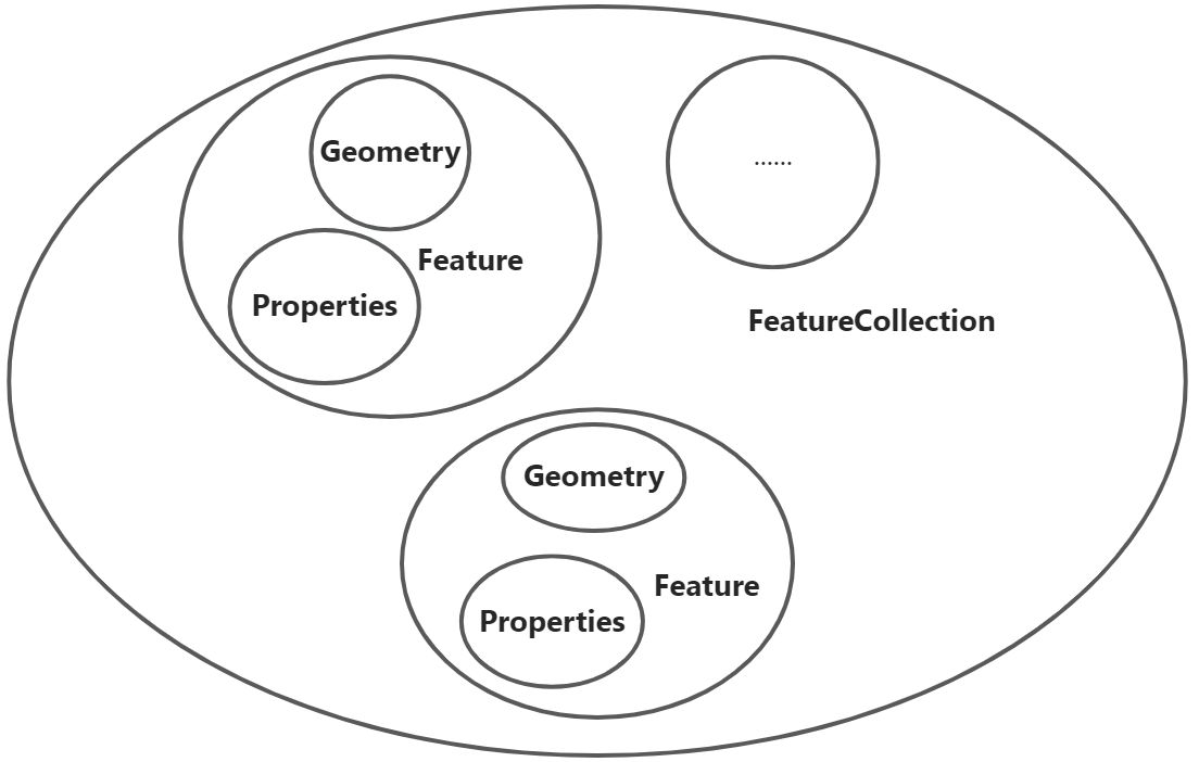 图2几何对象包含结构图
2. GeoJSON对象结构特点
GeoJSON对象表示几何对象(Geometry)、要素对象(Feature)、以及要素类对象(Features)的集合(FeatureCollection),具有如下特征。
每一个 GeoJSON对象都是JSON对象每一个 GeoJSON对象都具有一个type属性,其值必须是GeoJSON类型,以上九大类型之一。GeoJSON对象还可能具有"bbox"属性,其值必须是边界范围数组。GeoJSON对象还可能具有其他属性,如用户自定义属性。
3. GeoJSON几何对象
3.1. GeoJSON-Point
Point属性coordinates是一个数组,在投影坐标系中按[x,y]顺序显示,在地理坐标系中按经度和纬度[longitude,latitude]显示。
{
   "type": "Point",
   "coordinates": [100.0, 0.0]
}
3.2. GeoJSON-LineString
LineString属性coordinates是一个数组,元素为Point数组坐标对。
{
   "type": "LineString",
   "coordinates": [
       [100.0, 0.0],
       [101.0, 1.0]
   ]
}
3.3. GeoJSON-Polygon
Polygon属性coordinates是一个数组,元素为LineString线性环数组。数组的第一个元素表示外环,任何后续元素表示内环。无孔洞
{
   "type": "Polygon",
   "coordinates": [
       [
           [100.0, 0.0],
           [101.0, 0.0],
           [101.0, 1.0],
           [100.0, 1.0],
           [100.0, 0.0]
       ]
   ]
}
有孔洞
{
   "type": "Polygon",
   "coordinates": [
       // 外环
       [
           [100.0, 0.0],
           [101.0, 0.0],
           [101.0, 1.0],
           [100.0, 1.0],
           [100.0, 0.0]
       ],
       // 内环
       [
           [100.8, 0.8],
           [100.8, 0.2],
           [100.2, 0.2],
           [100.2, 0.8],
           [100.8, 0.8]
       ]
   ]
}
3.4. GeoJSON-MultiPoint
MultiPoint属性coordinates是一个LineString数组,元素为Point数组。
{
   "type": "MultiPoint",
   "coordinates": [
       [100.0, 0.0],
       [101.0, 1.0]
   ]
}
3.5. GeoJSON-MultiLineString
MultiLineString属性coordinates是一个数组,元素为LineString数组。
{
   "type": "MultiLineString",
   "coordinates": [
       [
           [100.0, 0.0],
           [101.0, 1.0]
       ],
       [
           [102.0, 2.0],
           [103.0, 3.0]
       ]
   ]
}
3.6. GeoJSON-MultiPolygon
MultiPolygon属性coordinates是一个数组,元素为Polygon数组。
{
   "type": "MultiPolygon",
   "coordinates": [
       [
           [
               [102.0, 2.0],
               [103.0, 2.0],
               [103.0, 3.0],
               [102.0, 3.0],
               [102.0, 2.0]
           ]
       ],
       [
           [
               [100.0, 0.0],
               [101.0, 0.0],
               [101.0, 1.0],
               [100.0, 1.0],
               [100.0, 0.0]
           ],
           [
               [100.2, 0.2],
               [100.2, 0.8],
               [100.8, 0.8],
               [100.8, 0.2],
               [100.2, 0.2]
           ]
       ]
   ]
}
3.7. GeoJSON-GeometryCollection
GeometryCollection属性geometries是一个数组,元素为geometry对象。
{
  "type": "GeometryCollection",
  "geometries": [
    {
      "type": "Point",
      "coordinates": [100.0, 0.0]
    },
    {
      "type": "LineString",
      "coordinates": [
        [101.0, 0.0],
        [102.0, 1.0]
      ]
    }
  ]
}
4. GeoJSON要素对象
要素Feature对象type属性为"Feature",由几何对象和属性信息构成。
{
  "type": "Feature",
  "geometry": {
    "type": "Point",
    "coordinates": [125.6, 10.1]
  },
  "properties": {
    "name": "Dinagat Islands"
  }
}
5. GeoJSON要素集对象
要素FeatureCollection对象type属性为"FeatureCollection",由features数组构成。元素是Feature对象。
{
   "type": "FeatureCollection",
   "features": [{
       "type": "Feature",
       "geometry": {
           "type": "Point",
           "coordinates": [102.0, 0.5]
       },
       "properties": {
           "prop0": "value0"
       }
   }, {
       "type": "Feature",
       "geometry": {
           "type": "LineString",
           "coordinates": [
               [102.0, 0.0],
               [103.0, 1.0],
               [104.0, 0.0],
               [105.0, 1.0]
           ]
       },
       "properties": {
           "prop0": "value0",
           "prop1": 0.0
       }
   }, {
       "type": "Feature",
       "geometry": {
           "type": "Polygon",
           "coordinates": [
               [
                   [100.0, 0.0],
                   [101.0, 0.0],
                   [101.0, 1.0],
                   [100.0, 1.0],
                   [100.0, 0.0]
               ]
           ]
       },
       "properties": {
           "prop0": "value0",
           "prop1": {
               "this": "that"
           }
       }
   }]
}
6. 注意
GeoJSON坐标对是经度在前,纬度在后,即[longitude,latitude]GeoJSON遵循右手规则,即外环为逆时针,内环为顺时针。GeoJSON数据都有一个type属性,Geometry对象为对应Geometry类型值,Feature对象为"Feature",FeatureCollection对象为"FeatureCollection"GeoJSON数据可能会有额外属性"bbox"或者用户自定义属性,"bbox"值为:["west", "south", "east", "north"],即[xmin,ymin,xmax,ymax]
❝
OpenLayers示例数据下载,请在公众号后台回复:ol数据
全国信息化工程师-GIS 应用水平考试资料,请在公众号后台回复:GIS考试
❝
GIS之路公众号已经接入了智能助手,欢迎大家前来提问。
欢迎访问我的博客网站-长谈GIS:
http://shanhaitalk.com
都看到这了,不要忘记点赞、收藏+关注 哦!
本号不定时更新有关 GIS开发 相关内容,欢迎关注